Since my last eLetter, I have been blessed with good climbing, and
have explored many other places as well. As it turned out, the next
day (the third day I was waiting for the weather to clear) from when I
was writing the last update on Mount Ruapehu was again very bleak
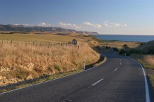
weather. I drove up to the ski area where one begins the climb of
Ruapehu, and confirmed that the summit was completely shrouded in
clouds. I thought about attempting the summit again, especially since
it looked sunny and inviting down in the valley, but knew that the
weather was dramatically different up higher. While trying to figure
out my plans for the next several days, I hiked around the interesting
rock formations near the ski area base, where some filming for the
Lord of the Rings was done. I finally decided to travel elsewhere and
do other activities for a few days, rather than continue to be stuck
in the rut of waiting for the weather.
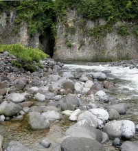
So, I drove a little north to the town of Taumarunui, where I hoped I
could find information on canoeing down the Whanganui River in the
Whanganui National Park. The Whanganui River is the longest
continuously navigable river in New Zealand, and I had read that the
best way to see this national park was to take a 3-5 day canoe trip
through the heart of the park on the river. Taumarunui, liked every
other major town in New Zealand, had a visitor information center,
called an i-site. Whenever I travel to a new region of the country, I
always first study my traveler's road atlas and then stop the i-sites
to gather free brochures and start to learn what attractions and
notable places there are in the region. Without these i-sites,
getting ideas about where to go next would be much harder. There were
several companies that rented canoes and provided transportation for
Whanganui paddlers, and I called around and made a reservation for a 3
day rental starting the next day. The rental, plus the mandatory
riverside DOC hut pass, cost a total of $165 NZD (about $110 USD).
After waiting so long at Ruapehu, I was excited to do something
different. Even though this is not a trail or walk, the paddling trip
is classified as one of New Zealand's 9 "Great Walks" which the
Department of Conservation have identified specially as being
representative of New Zealand's diverse environment.
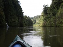
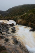
All three days on the river turned out to be nice weather, which was a
good thing especially since the river was already near flood stage
levels from all the rain we had been getting. I ended up paddling a
double kayak, since I didn't have a partner to canoe with, and I put
my dry-barrels up front to even out the wait. 12 other people launched
the same day with me, and we stayed at the same huts/campsites each
night, so it was nice to see and sometimes paddle alongside other
people. The total distance of 88 km was manageable and not too tiring
since the river was running so high and fast. While I only spent a
very leisurely 6-7 hours on the river each day, sometimes just
floating, I hear it takes much more work when the river levels are
lower. The Whanganui River was very beautiful; for most of its course
through the national park, it is a winding shallow gorge, with lush
green and steep sides, with innumerable small waterfalls tumbling into
the river from the banks. It has a few class II rapids, but mostly it
is flat water. My favorite parts of the river were these beautiful
waterfalls tumbling into the Whanganui. I also would paddle up side
canyons, beach my kayak, and continue to explore up the side slot
canyons by foot. Because I always kept stopping to explore these
amazing side slot canyons, I was usually the last one to arrive at the
hut each night. But I didn't mind, as the signs indicating a
downriver hut were hard to spot, and I probably would have floated
right by the hut if it weren't for all the other canoes pulled up
along the bank. The second day on the river was Christmas; it was
quiet but nice day. Since it is summer down here, it just didn't seem
like Christmas, but a few canoeists wore Santa hats all day, reminding
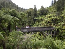
me it was indeed Christmas. Some of us took an hour side hike up to
the famous Bridge to Nowhere. Today this bridge spans a river, but has
no road at either end of it. It is really in the middle of nowhere, in
the middle of the wilderness. It was built in the 1930's to link an
upstart farming community of returning soldiers with the rest of the
world, but by time the bridge was finished, the valley had been mostly
been deserted because of its poor farming. Today, little evidence of
this farming community exists, except the Bridge to Nowhere.
I did enjoy the company of fellow paddlers during the trip, both some
similar-aged girls that are traveling around New Zealand and doing
much the same as me, as well as quite a few slightly older couples.
It seems that most travelers I meet here are European (with the vast
majority being German), Japanese, or Australian, rather than American.
I have also noticed a whole new generation of couples in their late
20's or 30's is traveling like me. They have quit their jobs back
home, and are just traveling around the world or just New Zealand for
a year or more; they stay in backpackers/hostels or rent a Volkswagen
van with a bed in back, etc. But I didn't see this as much 3-4 years
ago during my travels. Perhaps more people are recognizing that life
is too short to let to slip by unmeaningfully. Whatever the reason,
it is nice to know that I won't be the only person my age traveling
around and exploring, in years to come as I get older!
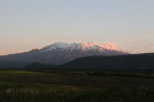
After being picked up, on the way back north to where I left my car, I
got my first view of Ruapehu unobstructed with clouds. It is a massive
mountain, the highest in the North Island at 2797m, and I was amazed
at the amount of snow you could see still on the mountain. Since it
was such nice weather that evening, I decided to drive back to Ruapehu
to make another attempt the next day. The mountain was clear in the
morning, so I got ready and hiked up the ski runs as fast as I could.
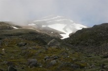
However, by the time I got to the crater rim, it was again completely
socked in with clouds, with zero long distance visibility. However,
the cloud layer wasn't thick, and it seemed the clouds were just
rolling over the top of the mountain, so hope remained. However, the
forecast did call for 80 kmph winds that day. Thankfully, I had
tracks to follow from hikers the past few nice days while I was on the
river, and while I didn't know exactly where they led, I was hoping it
was the summit. Actually, they led me in a half-circle back to the
emergency hut in the crater, so I decided to wait there for a couple
of hours. Thankfully, just as I was starting to freeze even with all
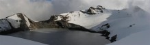
my clothes, an opening in the clouds blew over me. I could see the
huge Crater Lake, and the summit of Ruapehu across it, quite far from
where I was. Even though the terrain was soon enveloped in clouds
again, I memorized where to go, and headed off, around the lake.
Going was slow, as I occasionally had to wait and pray for a quick
glimpse of the mountain here and there to confirm where I was going,
but finally I made it up onto the summit ridge. The ridge sloped off
very steeply on one side down into Crater Lake (I thought-I still
couldn't see to the base of the bluffs I was on), and down the other
into the clouds and toward the south slopes of Ruapehu. I had my ice
axe, but not my crampons. I had asked the woman at the visitor center
at Whakapapa if I needed them, but she assured me I didn't need
them-in retrospect, I don't think she took me literally when I said I
wanted to summit the mountain, and had assumed I only meant to climb
to the crater rim. Grrrr! Finally, I got to a point on the rim
where I could not climb over the rocks in front of me, and I felt
uncomfortable traversing around them, since I didn't have crampons and
the snow was fairly firm, with an ice base below it. Just as I
contemplated turning around, the clouds lifted completely, so that I
discovered there was a nice flat plateau lying below the bluffs I was
on, between me and Crater Lake. I could follow this platuea along the
base of the crater rim I was on, and then make a steep climb up the
headwall from the inside side of the crater to just below the summit.
This route proved doable; the headwall climb was very steep, and I
chopped footsteps into the ice and snow with my axe, making the climb
very slow. However, I wasn't too worried, as this part of the headwall
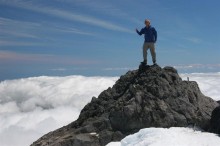
had an excellent runoff to the plateau below should I slip. Finally, I
chopped my way over the headwall cornice, and then had to scale an
equally steep pitch up the summit rocks. Here I chose to stay on some
rather icy rocks, rather than go out on the open snow slope, and to be
honest was quite scared without a belay. Thankfully, I didn't slip,
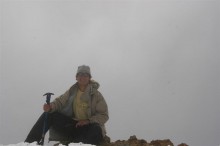
and made the summit. The weather had cleared by this time, and I was
amazed at the sheer size of Ruapehu's summit craters and plains.
Descending the summit rocks was again scary, and I purposely made an
adrenaline pumping controlled slide down the headwall snow chute,
rather than climbing down. The rest of the descent was uneventful, and
I could see how far off route I had been on my previous summit
attempt. I made it back to my car after a 12 hour day. Ruapehu is a
major mountaineering challenge, even in the summer, but I love this
mountain.
The next day, I decided to drive west toward Mt. Taranaki/Egmont
National Park, to re-attempt this mountain. I was blessed with one of
the few clear days on this mountain. I ascended via the most popular
North Taranaki route, which by this time all the snow had melted off
of. Tens of other climbers summited the same day, but I was one of
the few with an ice axe, and I would like to thing I one-upped them,
because I passed quite a few climbers as I slid past them on a
parallel snow gully to the rocky/scree route. I made the return trip
in only about 6 hours, which is quite fast since the elevation gain on
this mountain is close to 2000 m. Mount Taranaki is a spectacular
mountain, which stands alone and rises up from the Taranaki coastline
to a height of 2518 m. While it is not a technical climb in the
summer, many world class mountaineers have called this mountain home,
such as the famous Sir Edmund Hillary.
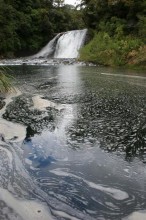
In the late afternoon after my climb, I drove around the mountain to
Dawson Falls for another view of the mountain I climbed (once you
summit a mountain, it is always nice to go to the touristy lookouts,
and say to yourself, "I was up there earlier today!") and took a
refreshing (cold) swim in some pools along a mountain stream. Also in
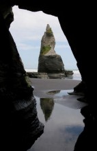
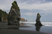
the Taranaki region, I walked along the beach beneath the White
Cliffs, and spend a day exploring the seacaves and arches and rock
pillars around the Three Sisters rock formations area, about an hour
north of New Plymouth. Mount Taranaki was visible on the horizon, and
the rock formations in the foreground provided excellent photographic
opportunities. This is perhaps my favorite section of New Zealand
coastline I have come across so far.
From here, I drove south and camped at some beautiful iron sand
beaches, then decided to drive back across the North Island to the
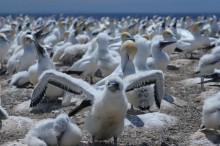
Napier/Hastings area to visit the Gannett colony at Cape Kidnappers,
and to spend New Years. The walk out to Cape Kidnappers took about 2
½ hours, and it was beautiful, though this area is extremely touristy.
I was nearly run over by all the private 4 wheelers and commercial
tractors pulling wagons of tourists along the beach to the Gannet
colony. However, seeing the thousands of birds so close (I was
allowed to stand as little as 1-2 meters from the birds and chicks)
was well worth my efforts. The actual Cape Kidnappers is also very
scenic, and is (like most beautiful places in NZ) rich in Maori
history and legends.
That evening was New Years Eve, and I met up with some Kiwi blokes
staying at the same hostel as I was, and we hung out together in
Napier for the evening. Fireworks at midnight are traditional in New
Zealand, and Napier put on a nice show, closing off all the downtown
streets for all the pedestrians to walk around in. On New Years day,
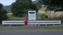
I drove south to the longest place name in the world, which just so
happens to be a hill. I saw this place on the map, and decided that
since I am into climbing the highest mountains around the world, why
not hike the longest (named) mountain in the world as well? Around 2
hours south of Napier, the hill is named
Taumatawhakatangihangakoauauotamateaturipukakapikimaungahoronukupokaiwhenuakitanatahu.
This is Maori; its translation reads something like, "The hill on
which Tamatea, the chief of great physical stature and renown, played
a lament on his flute to the memory of his brother." While I had no
clue what I was saying, I timed myself and pronounced the entire name
in 16 seconds. One can view the hill from the road, and there is a
large sign which displays the name of this hill and its history.
However, if you pay a $5 fee at the Waipukurau information centre for
a permit, you can hike about 1 1/2 hours over private farm land to the
top of the hill, which is 252 m above sea level. Of course I did this,
and it was a very rewarding experience, though crossing through the
fenced fields with all the cattle was a little disconcerting,
especially when the whole herd starts running toward you, not away.
(Cattle are naturally curious, apparently, and the information sheet
on the hill I got from the visitor centre says to just give a smack on
the cow's nose if it gets too close.) There are competing claims
elsewhere in the world for the title of the longest place name, such
as a town in Ireland; however, without any argument, this hill is the
longest mountain name in the world!
The following day was rainy and gale-force winds, but I decided to
hike for a day in the popular Tuatara Range north of Wellington, to
get a feel for what this range offered. Since I didn't have a map of
the range, I found a Mount Holdsworth, elevation 1470m, listed on my
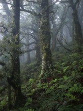
road atlas, and decided to go there. The moss-covered forest, shrouded
in dark clouds, was surreal to hike through, and my favorite part of
the day. The summit of Holdsworth involves about a half hour's hike
above treeline along a grassy ridge. The two parties ahead of me tried
to summit, but turned around because of the high winds and zero
visibility. However, I successfully made way to the top, dropping flat
on the ground whenever an especially strong gust of wind came. The
wind was a steady 70 kph, with gusts higher.
Hiking the longest place name in the world and in the Tuataras had
completed most everything I had wished to do in the North Island, and
I had planned to leave for the South Island then. However, while in
Napier I made a friend who lived in Wellington, so I decided to spend
a few extra days in the area. It is always more fun to explore a city
with someone else, and especially with someone who knows the area.
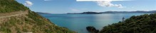
Among the things we did together, we drove out to the Cape Palliser
lighthouse and seal colony (the southernmost part of the North
Island), hiked up to the Putangirua Pinnacles where some filming for
the Lord of the Rings was done (it started raining when we were up one
of the narrow passageways, and little rocks being eroded in the rain
started falling on our heads (even a penny dropped from high enough
can kill someone-but I decided to not mention that fact till later)),
took a fairy out to Somes Island in the Wellington Harbour for a day,
walked along the Wellington harbour coastline to Pencarrow Head
lighthouse, and visited the national museum, Te Papa. All this was
very fun, but the time comes when one needs to move on, and so I
caught an overnight car fairy to Picton on the South Island. Since
then, I have done several epic backpacking trips, but that is for next
update, as by now you've probably stopped reading this lengthy one!
Cheers to you all! Have a great day!
Johnathan